There has been controversy for 25 years over the exact location of the Battle of Bosworth, the battle which saw the death of Richard III, the crowning of a new king, Henry VII, and the founding of a new dynasty, the House of Tudor. The controversy over the battle’s location was due to the conflicting information given in Medieval and Tudor records of the battle and artefacts found in the Leicestershire countryside.
Until February 2010, the three main theories were:-
- The Danny Williams/Ambion Hill Theory – Williams based his 1974 theory on the research of 18th century historians, Hutton and Nichols. Williams developed this research and concluded that Richard III’s army had gathered on the western slopes of Ambion Hill and the marsh on the southern slopes, Henry’s forces had approached from Whitemoors and the forces of Thomas and William Stanley had approached from Near Coton. The forces clashed due west of Ambion Hill, near Shenton and Richard died in this area. You can see a map of this theory at http://www.bosworthbattlefield.com/battle/archaeology/archaeology1.htm
- The Peter Foss/Redesmore Theory – This theory put forward in 1985 by Peter Foss was an attempt to match the evidence from contemporary sources with landscape evidence. Foss believed that the battle took place between Ambion, Dadlington, Stoke Golding, Upton and Shenton, in the area of low lying ground there. He believed that this area was Redesmore, the earliest recorded name for the battle site. As the dead were said to have been buried in Dadlington, Foss argued that the battle took place within its township. According to Foss, Richard’s army gathered on a ridge to the south west of Ambion Hill, Henry’s troops were on Fenn Lane and the Stanley forces were at Stoke Golding and Dadlington. He places the final battle just north of Stoke Golding, on Fenn Lane. See map at http://www.bosworthbattlefield.com/battle/archaeology/archaeology2.htm
- The Michael K Jones/Atterton Theory – This theory put forward by Michael K Jones in 2002 put Henry’s camp at Merevale, because the Crowland Chronicle recorded Henry giving compensation to Mancetter, Witherley, Atterton and Fenny Drayton for damage to crops during the battle, and Richard’s camp between Merevale and Ratcliffe Culey. Jones believed that the battle itself took place in the area south and east of Ratcliffe Culey.
The True Location of the Battle of Bosworth
However, in February 2010 Glenn Foard, the Battlefields Trust archaeologist, announced that due to a groundbreaking archaeological survey funded by the Heritage Lottery Fund, evidence had been found which proved the exact location of the battlefield:-
“Using the new techniques of battlefield archaeology we have recovered evidence which proves exactly where the iconic English battle was fought. The site, never before suggested as the battlefield, straddles the Roman road known as the Fenn Lane, near Fenn lane farm. It is three kilometres south-west of Ambion Hill and a kilometre west of the site suggested by Peter Foss.
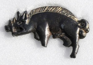
“The crucial archaeological evidence came from our systematic metal detecting survey. There may be relatively few finds from the battle, each of which has taken the team dozens of hours to locate, but several of the objects are amazing. The most important by far is the silver-gilt boar, which was Richard III’s own badge, given in large numbers to his supporters. But this one is special, because it is silver-gilt. It was almost certainly worn by a knight in King Richard’s own retinue who rode with the King to his death in his last desperate cavalry charge. It was found right next to the site of a small medieval marsh – and the King was killed when his horse became stuck in a mire.
“Other objects discovered as part of the survey include silver coins of Charles the Bold of Burgundy, a silver-gilt badge found close to where we believe the Duke of Norfolk was killed, and the largest collection of round shot ever found on a medieval battlefield in Europe. These artillery rounds, which range in size from 30mm – 94mm have redefined the importance of artillery at Bosworth and open a new, archaeological avenue of research into the origins of firepower on the battlefields of Europe.”
On the 15th April 2010, a new updated gallery full of archaeological finds from the battlefield, was officially opened by Dame Jenny Abramsky, Chair of the Heritage Lottery Fund at the Battlefield Heritage Centre. This gallery tells the story of how the true location of the battlefield was found and gives the public the opportunity to see evidence like the lead roundshot that was used in the battle. I visited the Battlefield Heritage Centre in July and it was wonderful to see the new gallery and artefacts from the battle, as well as enjoy the interactive exhibits. The exhibition is divided into different areas: the Road to Bosworth, Preparing for Battle, the Battle, the Surgeon, Winning the Peace, the Tudors and the BFI (Bosworth Field Investigation) research lab. It is a wonderful place to visit.
Notes and Sources
- True location of Bosworth Battlefield pinpointed press release.
- Bosworth Battlefield Heritage Centre website